|
|
 |
Location |
 |
|
 |
 |
Country: |
Italia |
Locality: |
Mompantero - Rocca del Chiodo |
|
|
Region: |
Piemonte |
Area: |
Valsusa |
|
|
|
|
|
|
|
| |
|
Environment & Surface |
|
|
|
|
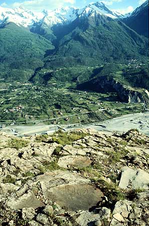
Altitude:
|
950 m
Open-air
Shelter
Cave
Portable
Megalithic
|
Geography: |
Terrace
on rocky slope, southward exposed, panoramic site, abandoned sheep
pasture, abandoned vines, xerophilous vegetation (Juniperus, little
pine-tree), stone walls, arid and windy area. |
Proximity: |
Path |
|
|
Geology: |
Filladic
calcschist (metamorphic rock composed by calcite and mica). This kind
of rock allows the pecking technique, but is more affected by the
erosion (water and wind) than the Permian sandstone, thus the siliceous
component, not soluble in water, is quite resistant. |
Surface: |
Smooth, microgranulated, flat, 10-15° of inclination, encrusted maroon lichens, patina |
|
Dimensions:
|
Length 1.06 m.
Width 0.64 m.
|
|
|
|
|
|
|
|
| |
|
Art |
|
|
|
Description: |
Engravings
Paintings
Painted engravings
High or low-relief
Sculpture
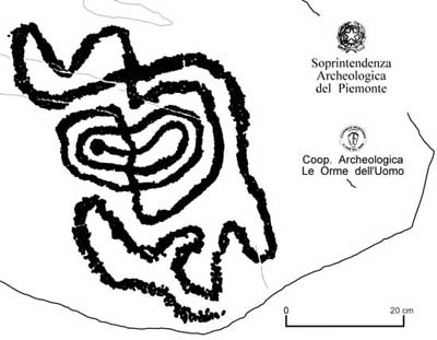
The little slab is a part of an engraved
surfaces group. The figure is constituted by a spiral prosecuting in a
meandering line. The pecking is much better preserved in the underground
(few cm) part. The figure (and all the meandering figures of this area)
is very similar to the meanders and spirals of the close Haute
Maurienne French valley (Plan des Glières, Arcelle Neuve sites), where
the altitude of the engraved areas is much more higher (over 2000-2000
m).
|
Figures: |
total number 1
Meandering spiral
|
|
|
Chronology: |
Palaeolithic
Epipalaeolithic - Mesolithic
Neolithic
Copper Age
Bronze Age
Iron Age
Roman
Middle Age
Modern
Unknown
This is a problematic subject to be dated. It's
possible to find a double chronological attribution: Neolithic-first
Copper Age (by comparison with the meanders and the spirals of the Irish
passage graves and of the megalithic art) or Bronze Age - First Iron
Age (by comparison with the engravings of the Haute Maurienne French
valley where such patterns seem to be related to the Iron Age
topographical compositions). The study of the superimpositions in the
Valsusa area testify that the meandro-spiralic pattern is overlapped by
late Iron Age figures, like axes.
|
Notes: |
The
entire area was terraced and cultivated (vines, potatoes) till the
'50-'60s. No water available if not through artificial channels. It's
one of the possible ways to reach the top of the Rocciamelone mountain
(more than 3500 m), the highest mountain in the Susa valley, where
traditional pilgrimage is still practised (the Holy Mary of the
Rocciamelone, https://www.rupestre.net/archiv/nat3.htm). |
|
|
|
|
| |
|
Bibliography |
|
|
|
|
|
| |
|
Conservation |
|
|
|
Status: |
Public
Private
Park
Classified site
|
Risk: |
Figures
are visible only on a grazing light. The site is poorly attended, thus
some people is passing with motorbikes along the mountain path. The
surface is affected by the erosion. The area is rarely covered by snow. |
|
|
Conservation: |
Good
Quite good
Mediocre
Bad
|
Intervention: |
The
rock has been completely recorded (International western Alps rock art
record), traced (contact tracing and digital vectorial rendition),
photographed (normal light and grazing light colour slides) under
enchargement of the Archaeological Superintendence of Piedmont. More
info (Italian version) at http://rupestre.net/archiv and http://rupestre.net/alps. |
|
|
|
|
|
|
By |
|
|
| |
| 494 / 806 |
Specific © is mentioned in the captions or owned by each Author or Institution |
|
| |
|