|
|
 |
Location |
 |
|
 |
 |
Country: |
Italia |
Locality: |
Mompantero - Costa Seppa |
|
|
Region: |
Piemonte |
Area: |
Valsusa |
|
|
|
|
|
|
|
| |
|
Environment & Surface |
|
|
|
|
Altitude:
|
1015 m
Open-air
Shelter
Cave
Portable
Megalithic
|
Geography: |
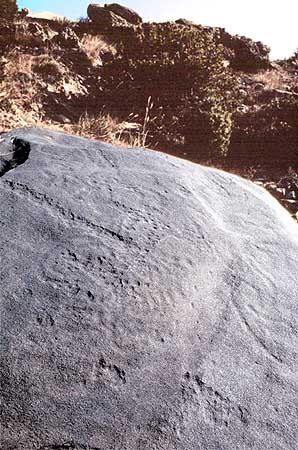
Rocky
slope, southward exposed, panoramic site, abandoned sheep pasture,
xerophilous vegetation (Juniperus, little pine-tree), stone walls, arid
and windy area, lateral morainic pudding-stone deposits. |
Proximity: |
Path |
|
|
Geology: |
Filladic
calcschist (metamorphic rock composed by calcite and mica). This kind
of rock allows the pecking technique, but is more affected by the
erosion (water and wind) than the Permian sandstone, thus the siliceous
component, not soluble in water, is quite resistant. |
Surface: |
Smooth, convex, microgranulated, flat, 30° of inclination, patina |
|
Dimensions:
|
Length 1.50 m.
Width 1.50 m.
Depth 0.30 m.
|
|
|
|
|
|
|
|
| |
|
Art |
|
|
|
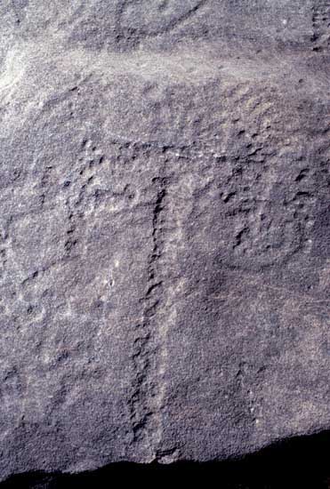
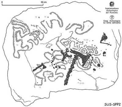
Description: |
Engravings
Paintings
Painted engravings
High or low-relief
Sculpture
The three axes are quite different: the first
is very large and the second much more tiny, thus of the same shape.
They seem to represent a couple, like in CHM2 rock, and they overlap the
underlying meandering figure. The third axe is tiny with a very thin
handle, quite strictly recalling some little votive axes of the
Gallo-Roman period (like in the Roman-Celtic sanctuary of Thoune -
Allmendingen, Switzerland-). The pecking of the axes is also larger than
the pecking of the meanders, which are more eroded. Two meandering
figures take origin from the typical round little-cup-mark.
|
Figures: |
total number 35
3 axes, 1 unidentified tool connected with the axe, 5 meanders, 1 modern letter "V", sparse dots or groups of pecking
|
|
|
Chronology: |
Palaeolithic
Epipalaeolithic - Mesolithic
Neolithic
Copper Age
Bronze Age
Iron Age
Roman
Middle Age
Modern
Unknown
The axes are very similar to the late Iron Age
axes (I cent. BC - I cent. AD, in this period the area was occupied by
the Celtic people called "Segusii", after the 9 AC the Romans). The
meandering subject is a problematic one to be dated. It's possible to
find a double chronological attribution: Neolithic-first Copper Age (by
comparison with the meanders and the spirals of the Irish passage graves
and of the megalithic art) or Bronze Age - First Iron Age (by
comparison with the engravings of the Haute Maurienne French valley
where such patterns seem to be related to the Iron Age topographical
compositions). The study of the superimpositions in the Valsusa area
testify that the meandro-spiralic pattern is overlapped by late Iron
Age figures, like the axes of this rocks which clearly cut the meanders.
|
Notes: |
Looking
at the engraved surface in the complex it seems evident that the rock
has been reversed, probably coming from the terrace above. In this case
it is possible that the slab was dressed, like a stele. The entire area
was terraced and cultivated (vines, potatoes) till the '50-'60s. No
water available if not through artificial channels. It's one of the
possible ways to reach the top of the Rocciamelone mountain (more than
3500 m), the highest mountain in the Susa valley, where traditional
pilgrimage is still practised (the Holy Mary of the Rocciamelone, https://www.rupestre.net/archiv/nat3.htm). |
|
|
|
|
| |
|
Bibliography |
|
|
|
|
|
| |
|
Conservation |
|
|
|
Status: |
Public
Private
Park
Classified site
|
Risk: |
Figures
are visible only on a grazing light. The site is poorly attended, thus
some people is passing with motorbikes along the mountain path (the rock
is just on the path). The surface is affected by the erosion. The area
is rarely covered by snow. |
|
|
Conservation: |
Good
Quite good
Mediocre
Bad
|
Intervention: |
The
rock has been completely recorded (International western Alps rock art
record), traced (contact tracing and digital vectorial rendition),
photographed (normal light and grazing light colour slides) under
enchargement of the Archaeological Superintendence of Piedmont. More
info (Italian version) at http://rupestre.net/archiv and http://rupestre.net/alps. |
|
|
|
|
|
|
By |
|
|
| |
| 499 / 806 |
Specific © is mentioned in the captions or owned by each Author or Institution |
|
| |
|